Weather: First Summer Heat Wave in the Triangle
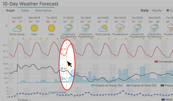
Cary, NC – Summer officially starts on Saturday, June 21, 2014. Just in time, the summer’s first heat wave is closing in on the Triangle.
First Summer Heat Wave Closes in on Triangle
After a cold winter and a cool spring, temperatures will be boiling the mercury for the next few days.
[ezcol_1half]
Day
Tues 6/17
Wed 6/18
Thurs 6/19
Fri 6/20
Sat., 6/21
Sun 6/22
[/ezcol_1half] [ezcol_1half_end]
High Temp
92°
96°
98°
97°
95°
96°
[/ezcol_1half_end]
No Relief Until Next Week
According to Wunderground, there is little chance of rain on Wednesday. Check out cool, interactive charts.
As the heat wave unfolds, chances of an afternoon thunderstorm will rise through the weekend.
At this point, the weather looks steamy until the middle of next week.
Stay Safe in the Heat
Temps above 90° during the midday can be dangerous. Drink plenty of fluids, find a patch of shade or wear a hat if you’ll be outside.
Young children and older folks can dehydrate quickly. Stay indoors if possible during the hottest part of the day.
Pets can be at risk, too. No, it’s not ok to leave Fido in the car while you nip into the supermarket.
Be safe, visit the pool, or plan outdoor activities for the cool of morning or evening.
More Weather Facts
- Average High/Low in June: 87°/66°
- Record High/Low in June: 105°/43°
- Average High/Low in July: 90°/69°
- Record High/Low in June: 107°/52°
- Month to Date Rainfall: 1.74″
- Average Rainfall in June: 4.66″ (wettest month of the year)
Roll Your Own Weather Forecast
Weather geeks and budding information scientists can browse deep data sets on the National Climatic Data Center.
KMZ files, tools for mapping – lots of fun stuff.
———————————————————————————————-
Meteorological date from Weather.com and NOAA.gov. Photo by Daniel Matthew.


