Cary Weather: Snow Alert for Monday Evening
Cary, NC — It’s been a tough winter for Boston and New York. Now, some of that snow may be coming to the Triangle on Monday afternoon.
Snow Alert for Monday
Arctic air has already pushed into Cary with overnight temps in the teens.
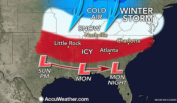
Now, warm and moist air is pushing across from the Gulf of Mexico, mixing with the arctic blast, creating the perfect conditions for snow and ice from Kansas to North Carolina.
The wintry mix will come over the Appalachians Sunday night. AccuWeather predicts a snow and ice for Cary starting around 5 PM on Monday continuing through midnight.
From the National Weather Service:
Snow likely before 1am, then snow and sleet likely. Cloudy, with a low around 24. Light and variable wind becoming northeast around 6 mph in the evening. Chance of precipitation is 70%. New snow and sleet accumulation of 1 to 3 inches possible.
Dangerous Driving
Snow will be bad; ice will be worse. Roads will be slick and patches of black ice may appear.
Pay attention to local forecasts Monday morning and plan to get home before the wintry mess arrives.
Snow? Or Ice?
Currently, forecasters are predicting the snow/ice line will run from Charlotte to Fayetteville.
That puts the Triangle just to the north of a zone of icy precipitation that could stretch south to Columbia and Atlanta.
A light snow in the Triangle would be scenic and not too disruptive. But ice brings down trees and power lines, so let’s hope we stay above the change-over line.
Very Cold Week Ahead
Temperatures will stay very chilly in Cary. Wednesday may reach 34°F, but after that, temps plunge.
Lows Wednesday and Thursday night may drop to 9°F.
Temps aren’t expected to rise above 40°F in Cary until next weekend.
Stay warm, people.
More Resources
- AccuWeather
- National Weather Service
———————————————————————————————————————————————
Story from staff reports. Weather map from AccuWeather.