Tech Tank Review: Cary Bike & Hike App
Cary, NC — On January 12, 2015, the Town of Cary released a new municipal mobile application, the Cary Bike & Hike App. Technology Tank undertook a survey to get user feedback on the new app.
Cary Bike & Hike App Survey
Our pool of reviewers came from TechTank (TT) Fellows as well as interested readers of the Tech Tank Journal, so we can assume that the reviewers were more techie than the general app using public. Of those asked, the respondents all turned out to be male and were fairly evenly split between Android and iOS users. Most of the reviewers took 15-30 minutes to review the app and a few took more than an hour.
All our respondents are Cary residents. Some are avid users of Cary greenways, others occasional or infrequent users.
Top Line Survey Results
- Getting the App – The respondents were split between “easy” and “difficult” and these answers were mixed between the reported device types.
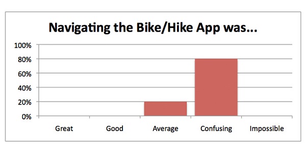
- Navigating the Bike/Hike App was… – Most respondents chose “Confusing”
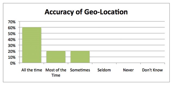
- Did the app geo-locate you accurately? – Most respondents chose “All the Time”
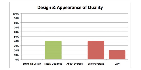
- Design & Appearance of Quality – The respondents were split between “Nicely Designed” and “Below Average” and these answers were mixed between the reported device types.
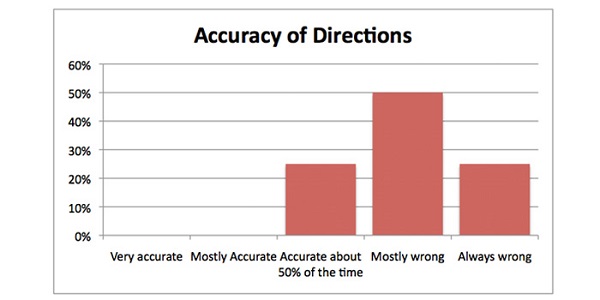
- Accuracy of Directions – Most respondents chose “Mostly Wrong”
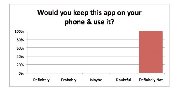
- Would you keep this app on your phone & use it? – All of the respondents replied “Definitely Not”
Tech Tank Analysis
Design
The opinion about design and appearance of quality looks to be split 40% (good) to 60% (not so good). The split in opinion of the design and appearance is interesting, and a follow up with a design specialist may be able to determine why. TT Fellow Hal Goodtree observed that:
The respondent skew toward technology-types probably devalued the actual impact of design (or lack thereof).
Navigation & Usabaility
Most respondents found navigation and using the app to be confusing.
Geolocation
On the plus side, the majority of our respondents found the geo-location capabilities of the app to be good. Geo-location is the ability of the app to know where you (the user) is located to make it possible to show nearby trails and give directions.
Directions
On the negative side, all our survey respondents thought the directions from user location to trailhead were inaccurate.
One of our respondents looked for the trailhead nearest his house. The Bike & Hike App found the appropriate trail, but gave directions to the nearest entry point as 2.1 miles away, an 8 minute car ride. In reality, the nearest entry point is 500 yards from the home of our respondent, approximately a 4 minute walk.
Tech Tank believes that lack of accuracy in user-to-trail directions is a fatal flaw in Cary’s Bike & Hike App.
Keep It On Your Phone?
The proof of a good app is if people will keep it on their phone and in this case, all of our reviewers chose the emphatic “definitely not.”
Most users of mobile devices actively engage with less than a dozen apps. These include phone, text, music, email, maps and the camera. The bar is set high on building a useful app.
Studies show that mobile users spend 1-2 minutes deciding whether or not to keep an app. Our reviewers spent a much more generous amount of time, but none felt they would keep the app.
Additional Feedback
In addition to the survey, we have heard from many citizens about the release of Cary’s Bike & Hike App. Much of the feedback has been unfavorable.
Several citizens have asked why the Town would commission the app when there was already the very successful RGreenway regional trails app. Others have observed that a local supplier would have the advantage of more extensive testing than a developer in Bellevue, WA.
If you are interested, you can take the survey.
Download the App for Yourself
Visit Town of Cary and follow the links to download the Cary Bike & Hike App for yourself (available for iPhone and Android).
Let us know what you think!
————————————————————————————————————————————
Story and photo by Ian Henshaw. Hal Goodtree and Ian Cillay also contributed to this story.
Disclosure – Tech Tank was a bidder for the Town of Cary Bike & Hike App RFQ.




We appreciate the feedback on our Bike and Hike mobile app. We have addressed many of the views expressed here on our website at Get the Facts – Bike and Hike App: http://www.townofcary.org/Departments/townmanagersoffice/pio/bottomline/getthefacts-bikehikeapp.htm
Thanks for the update, ToC! Keep pushing the envelope.
It lacks a greenway button! Incredible.
Please keep TOC staff informed, especially those that paid the firm over $40K!
I’m a recumbent bicyclist (68) and not fond of sharrows and all the distracted drivers on the roads.
Cary tried to put and incredibility confusing glossy paper map into an app. It’s a planning-type one-size-fits all map that is just to darn busy.
I’d be so happy with a downloadable pdf file in black & white that showed me CURRENT paved greenways.
Maybe an Eagle Scout could do it as a project for free?